Wirral Page 1 Page 3 Page 4
Update 2 April 2018
![]()
![]()
![]()
![]()
Wirral Page 1 Page 3
Page 4
Update 2 April 2018
PAGE 2
(See also Moreton Youth Club) Moreton Cross Leasowe Lighthouse Old Hall Farm Stavordale Garage & The Marcos Shanty Town Moreton Shore
Ken Burnley's Moreton
(we were both born the same year and probably passed each other a
zillion times in the 'olde' Moreton)
The following is reproduced with permission from Images of Wirral By Ken Burnley
& Guy Huntington
|
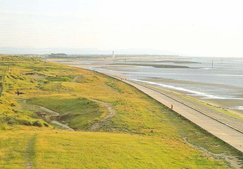
My childhood days were spent in Moreton. I grew up within a stone’s throw of the north Wirral coast, with its grassy common land behind the embankment, rich in buttercups and clovers. The sea dominated our lives in so many ways, its salty tang carried across the flat, wind-swept plains by restless breezes; the mysteries of the opposite sex being discovered in the warm, sandy nooks of the quiet dunes and, in later years, pleasures of a different kind, in the delight of discovering uncommon plants and flowers in those very same dunes. You either love it or you hate it — this treeless expanse, these few miles of coastal plain fronting the Irish Sea. Its very open-ness disturbs many folk - there is nowhere to hide, nowhere to run, from the ceaseless wind and the frequent squally showers blown in from the sea. There are few trees - and those that survive, are bent double away from the west and the prevailing wind. And yet, there are days in summer - few enough indeed - when the warm sun shines, the skies are blue, the wind dies down for a while. These are days to be savoured: to search out rare flowers in the long meadow—grass: ragged robin, orchids, and yellow button; to laze on the soft, warm turf, listening to the skylarks singing high above, with the faint murmur of the surf on the incoming tide; or to stroll along Meols promenade, enjoying the sight of the small, colourful boats gently bobbing on the quiet tide. Delightful. I share Kens memories, see my story of Gina in the Sand Hills mentioned somewhere!! |
|
|
|
What changes this part of the
Wirral coast has seen: in olden days the Irish Sea was free to pour inland
across these low-lying plains, as far as Overchurch and towards Bidston. Only
the concrete embankment saves these lands from inundation today. At the opposite
extreme, the Wirral peninsula used to be longer than it is today; tidal waters
now cover lands once inhabited by man and beast. Seek out the evidence for this
in the tree—trunks and peat—beds of the submerged forest on the shore between
Moreton and Meols. Six thousand years ago, these parts now covered twice daily
by the Irish Sea tides, were forest lands: men hunted here, their game being red
deer. Later, much later, the Romans used this northern extremity of the Wirral
peninsula as an outport. |
|
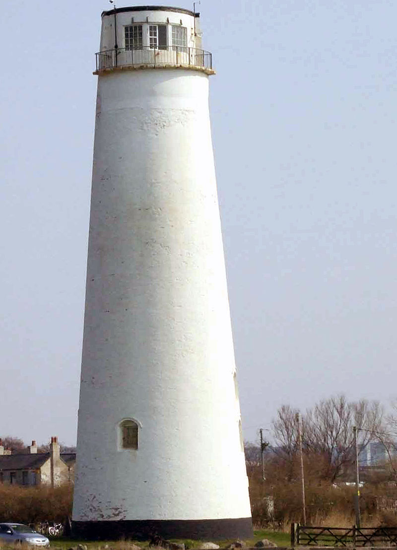
Leasowes light may be
over 200 years old, but it gazes across the windswept grassy meadows
towards something much older — and another guardian, of sorts. Leasowe
Castle, grim as all good castles should be, has been here on this desolate
marshy flood plain for nigh on 400 years. Of course, bits have been added
to it over the years, and its original single tower is barely discernible
at the heart of the cluster of buildings that rejoice in the name of
’castle’. But the grey stone turrets are there, and it’s not too difficult
to imagine this as some defensive fortress to protect its founder,
Ferdinand, Earl of Derby, way back when lawlessness was rife around here.
They say he was involved with the popular horse-racing that went on by the
sea here, and which eventually gave its name to the national Derby race of
today. (Leasowe Castle is now a hotel - mk 2011) |
|
|
|
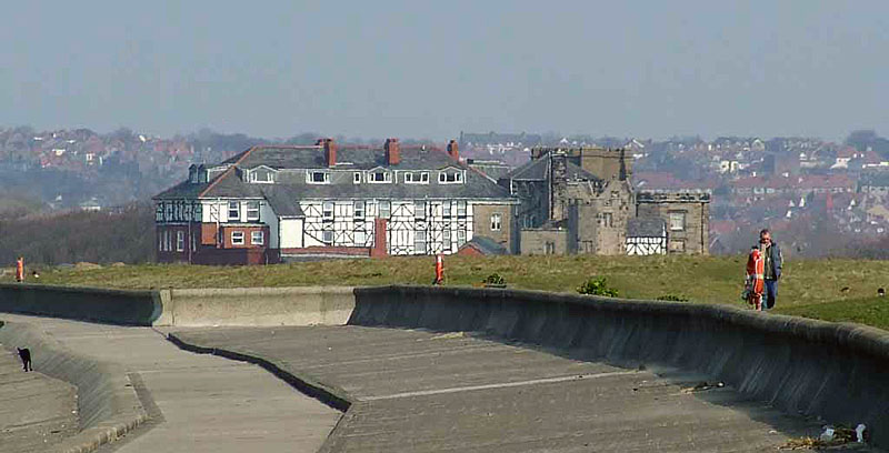
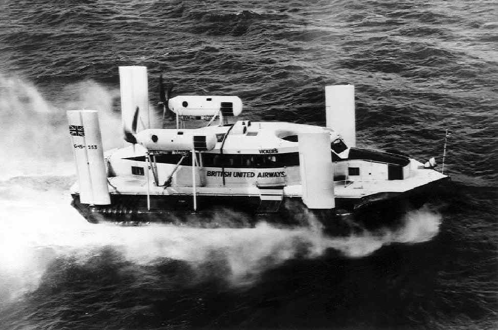
It has almost swallowed
up pretty little Saughall Massie, its farms and cottages. But we are
getting too far from the coast. And talking of the coast, did you know
that the world’s first scheduled passenger
hovercraft
service operated between Moreton and Rhyl in l962? Another Wirral first. A
far cry from those days, romantically portrayed by a tourist, as he walked
along here earlier this century: |
|
|
|
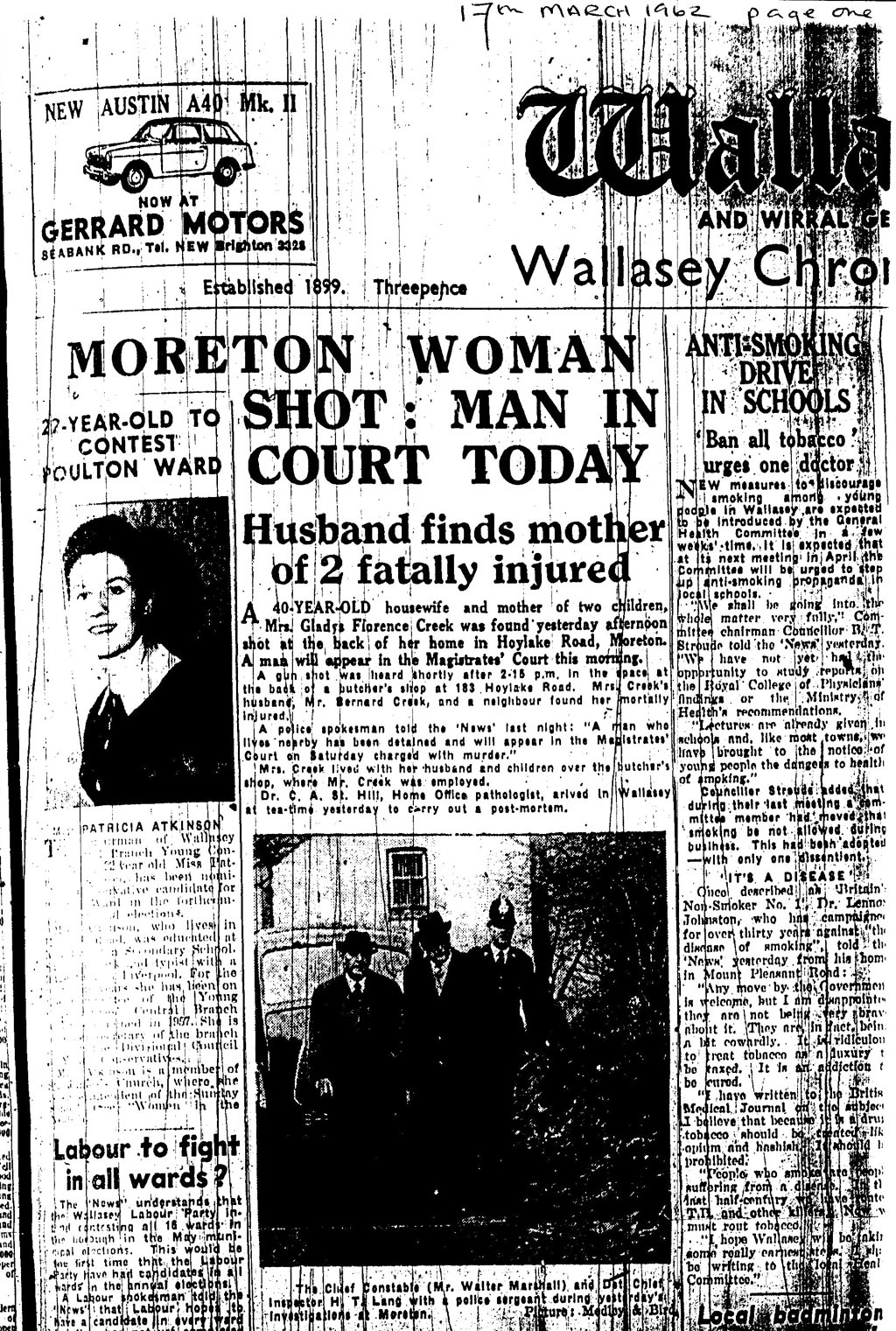 |
17th March 1962. Underneath the
headlines the text says: A 40 year old housewife and mother of two children, Mrs Gladys Florence Creek was found yesterday afternoon shot at the back of her home in Hoylake road, Moreton. A man will appear in the Magistrates Court on the morning. A gun shot was heard shortly after 2-15pm in the space at the back of a butchers shop at 183 Hoylake Road. Mrs Creek's husband, Mr Bernard Creek, and a neighbour found her mortally wounded. A police spokesman told the News last night "A man who lives nearby has been detained and will appear in the Magistrates Court on Saturday charged with murder". Mrs Creek lived with her husband and children over the butchers shop where Mr Creek was employed. Dr C A St Hill, Home Office pathologist, arrived in Wallasey at tea time yesterday to carry out a post mortem. The caption under the image reads: The Chief Constable, (Mr Walter Marshall) and Det Chief Inspector, H T Land, with a police sergeant at yesterdays investigation at Moreton. Thanks to Jim Talbot for this piece of Moreton drama and history. |
|
I was born in the Highfield Maternity Hospital, Mill Lane, Wallasey and started the first part of my life in Moreton in Burrel Drive. However, the walking distance to Barnston Lane Infants School was too great for my 4½ year old legs and we moved closer, to Fairfield Crescent.. The Luftwaffe found us there in about December 20th1940 and blew the fronts off the neighbours’ houses (see Moreton Wirral, A Pictorial History Vol.3, page 59. The Dates attributed to the raid in the “History” are incorrect.) For the next three months we lived in rooms of the Deans’ house in Glebelands Road (Mr Dean ran the Post Office on Hoylake Road close to the bus stop at the Cross, before it moved to Chadwick St.) However, the Luftwaffe found us again and blew the back off the house sometime about 20th March, 1941. (could have been the May 1941 blitz) Fearing that the third time might be “lucky” for the bombers we evacuated ourselves to North Wales before returning to Moreton in 1944. Jack Woollam, and his family, jumped from the “frying pan” of Wavertree bombing in 1940, only to come to live closer to “the fire” in the old Brooklands House which was a short distance from the house in Glebelands Road. I wonder whether they were aware of how close they had come to becoming the target following their escape from Liverpool. Comments which reached my 5-year old ears suggested that the bomb had penetrated deeply into a ditch, causing the blast to be deflected upwards. I remember the event, from the vantage of the Deans’ living room, very well. We returned to a Moreton in 1944 (see 1945 map which one of your correspondents has kindly attached to an email.) It was a Moreton with much of the old farming village still intact. Holt Avenue was an “unadopted” lane with a cinder roadway and an old orchard on the corner with Hoylake Road. A walk from home, down towards the shore, along the paved Digg Lane soon gave way to the cinder track of Lingham Lane. On either side were farmers’ fields stretching to the Barnston Lane School on the one side and to Burden Road on the other, bounded by large hawthorn bushes, the lane itself being a repository of old prams, bicycles and other household detritus. Maryland Lane and Town Meadow Lane were equally unpaved, although pedestrians were “separated” from the traffic by kerb stones set into the cinders . An anomaly in all this lack of development was the small estate along Eleanor Road which may have been built before the Great Depression of the 1930s took hold. The railway crossing marked a continuation of the cinder track and pedestrians crossed at their own risk through a swing gates on either side. Occasionally, we would place the already large penny coins on the rails to watch the train compress them into very much larger copper tokens of no increase in monetary value. On the other side of the tracks there was a field to the left which was about 200m long and which led to Black Harry’s Pit. Apparently the pit had been formed by excavations which had been made to build up the railway embankment at the turn towards Meols. Rain water had filled the resulting hole and fish had been added to the pond by the founders of the fishing club which demanded the purchase of a licence to drop a line in. I spent many a drowsy hour with my father in the pursuit of the “big one” inhabiting the middle but only caught small rudd and roach. The fishing was better following a turn to the right after the railway tracks and a walk along the steep embankment bordering the Briscoe and Jones brickworks excavations. The bucket chain machines reached down some 30-40ft, depositing their scrapings into small trucks towed along a narrow gauge railway by a continuous wire cable. The pit so formed was vast and rainwater had produced a large pond which was filled with larger roach and rudd than Black Harry’s, as well as a carp-like fish called a tench. These much larger fish were caught by anglers, wearing hip waders, who ventured into the deeper reaches of the system. Next to the brick works, on Pasture Road, was Fellowship Field where Moreton, in celebration of the return of peace, held a Fete in 1947. It was a miserable day with the intermittent rain soaking the field but, with my last pennies I purchased a small flag on a toothpick, wrote my name on the flag and planted it in an area where the treasure was buried. I went home that evening 10 shillings the richer and deposited that large sum of money into my savings. The field was soon put to another good use when they assembled prefabricated houses on concrete pads to form the new subdivision of Tarran Way and Close. The Lane wandered on to the sea wall through the yard of a farm which, I think, belonged to one of the Biddle Family. In those days, the lighthouse was closed and in great need of repair. The embankment was also suffering from the depredations of the pounding surf, with number of the surface sandstone blocks worn thin and lifted out of their settings. Since any wartime invader could easily surmount the embankment, various forms of “tank traps” had been placed on the upper levels. These were often cubic concrete blocks and 4ft high tetrahedra (Page 2 above) and, postwar, afforded suitable windbreaks to sunbathers and people on picnics. We called these latter obstacles “Dragons’ Teeth”. I cannot think of a good reason for their removal, unless they were ground up and reused in embankment repairs. The replacement of the worn sandstone blocks came with problems for bathers. In 1953, a group of us left our bicycles and clothes on the embankment opposite to the Childrens’ Hospital , donned our swim suits ,and entered a rough swell which had followed a storm. While in the water we bobbed up and down without a care but, on attempting to return ashore on the crest of a wave, we found that the outflow of the spent wave washed us down to the bottom of the embankment under an oncoming wave. The concrete resurfacing was without handholds especially with its covering of a moss. We did escape by the simple expedient of swimming along to the Leasowe Sand Hills (The removal of these hills seems to have been one of the most idiotic decisions made by the local authorities) and walking back to our bicycles. At the junction of Pasture and Leasowe Roads there was a small fairground arcade in which children placed large numbers of pennies in slot machines which gave nothing in return. It was often overseen by a couple of grim looking women who suspected every child to be attempting to cheat these “dishonest” devices. However, the most significant memory of the place was the very limited selection of music they played repetitively and very loudly; a mixture of “Colonel Bogey” and Stan Kenton’s” Peanut Vendor”. Living by the sea it was necessary to be able to swim and be confident in the water. We had available a choice of one indoor and three outdoor bathing pools. The Guinea Gap was a crowded and, to my mind, a dangerous place in which to learn to swim. Hoylake, on the other hand had an easily accessible pool (by Crosville Bus) which was usually almost empty. Left to myself, I faked the process in the shallows until, one day, I slipped into a place where I was out of my depth and, to my surprise, did not drown. After drying and changing, we often gathered round the Bryl Cream dispenser where one of the fellows paid the usual penny fee and slowly pumped the plunger ¾- way in, allowed the plunger to extend back to ¼- way and repeated the process. Instead of a one shot supply, we had enough to slather over all of our heads and we strode off looking like a group of Denis Comptons. Our walk home along the sea-front often led to an exploration of tidal pools, submerged stumps of the ancient forest and the odd fishing boat left high dry by the ebb on the Meols Shore , and we saved the return bus fare. New Brighton swimming pool was a huge semicircle which shelved from a deep (12ft) centre to nothing at the circumference. The deep rectangular pool and high diving boards lay along the diameter. It was popular with families of small children and those who came to ogle the bathing beauty contestants. During the latter proceedings, swimmers were allowed into the water but ushers (nowadays, security) prevented the swimmers from hanging on to the bars at the edge of the pool. In order to obtain a closer look at the “bathing suits which never got wet” (as sang Nat King Cole) the swimmer had to tread water. But rather than waste time at New Brighton, the youth of the day went to the Derby Pool. A place to sunbathe, display and occasionally swim. What a reverse in swim fashion has occurred over the intervening years. In those days, mens’ “trunks” were brief while the young women wore relatively modest single piece suits. Nowadays, young men wear shorts which might be seen on hikers, boxers and basketball players whereas young women wear as little as is practically possible. Perhaps I am blessed with myopia. With all of these venues now gone, what do the local youth do when they get their noses out of their cell phones and computer screens? My father was one of two supervisors in the Moreton Mail Sorting Office on Chadwick St., and sometime in 1946-7, the Liverpool Head Office sent him a blue print of the impending developments to the Moreton area for the local postmen to study. These fellows were expected to memorize the plans over a couple of days since the bureaucrats in Liverpool demanded a return of the document so that it may be put to better use mouldering in some obscure cabinet at Head Office. It became my job to copy the maps on to large sheets of tracing paper, the copies later being stuck to the walls of the dining area of the Sorting Office. Many years later, they were still there. This meant that, for what it was worth to me, I drew the developments between Danger Lane and the Cross and Hoylake Road and Eastway. Later it was the Leasowe Road at Murrayfield Drive and Pasture Road at Yew Tree Close. Les Turner’s Tobacconist’s Shop is referred to by many of your correspondents. In the alleyway from The Cross to Oakenholt there was a small radio shop which, on a cold winter’s evening in 1951, had a TV on display. Reception from Sutton Coldfield was fitful and often subject to “snow” (interference from the remnant of the Big Bang), but I spent part of that evening watching an ice hockey game between the Brighton Tigers and the Nottingham Panthers, including a feature on the late and great Chick Zammick. All free of the blather of a commentator who was inaudible to the group huddled up against the glass window in the cold evening’s air. Despite the occasional vandalism, the Moreton Cross, when it became the kidney-shaped flower garden, was a splendid decoration to the centre of the village. Traffic moved smoothly in the single lane circuit and those on foot could walk across to admire the flowers from close up. However it appears that the modern denser traffic has to be protected from the pedestrians by means of an ugly barrier and white lines separate the jostling cars as they seek to pass each other in the most inappropriate places. The complicated system of traffic lights and lanes is a poor substitute for the round-a-bout at the junction of Reeds Lane and Hoylake Road. The road engineers had banked the circuit ( Like the Carousel on the late Nurnbergring German Grand Prix Circuit.) which gave the Birkenhead bus drivers some fun as they “rocked and rolled’ past on the exit from Fender Lane. These circles and rotaries permit a much more fluent passage of traffic than the lights, which often hold the traffic up with nothing passing along the other road. For an exercise in the use of a traffic circle, try the multiple system in Swindon. During some of our frequent rambles about the neighbourhood ( The only restriction being that we return home in time for the next meal.) we ventured to Saughall Massie and the crash site of a “Yankee Bomber”. The small mount at the edge of a field, with some pieces of aluminium poking through the surface seemed a bit small to represent the remains of a bomber . However, I take my hat off to those who had the site excavated and organized the visit of the pilot’s relatives at the placing of a plaque of commemoration on the bridge over the Arrowe Brook. ( this yankee bomber was a Thunderbolt fighter. See the link to my war site). There was a bomber crash but that was at Landican.) I wonder if there was already a plaque on the bridge since this was the first engineering project completed by the great Thomas Brassey whose company built many of the railways round the world in the 1850s. He turned the village of Birkenhead into an industrial powerhouse making all equipment for road and rail building. I used to live 3 km from his greatest triumph (1859) in the Grand Trunk Railway which joined Montreal and Toronto (539 miles) including the Victoria Bridge which spans the St Lawrence at Montreal (1.7 miles long). The supports for this bridge are still in place for the modern superstructure. Does the Wirral Hundred
Motorcycle Club still race on the Leasowe sands? Do they still run the
Wallasey Road Race for bicycles? The first race (ca 1950) ran from the
Harrison Drive Promenade through Moreton, up Thursaston Hill, across to
Ford Hil (a couple of circuits) and back to the start. It attracted some
major racing cyclists in those days. A final note on education. The Barnston Lane, Grade 8 class of 1945-6, was ruled by Miss Banks who was described as “strict” or, in modern terms “tyrannical”. Despite her prediction that only 1/6 of us would pass “the scholarship” (11-Plus,) 43 of us passed to the Technical or Grammar Schools in Wallasey . The 43 contained future Ph.D.s (3 Organic Chemists, 1 English expert on Shakespeare), 1 B.A. in Geography/Education, 1 Mining Engineer, 1 graduate of the Royal Academy of Dramatic Art, and 1 B.Sc. from Melbourne University in Australia. All from a class of working class children who took advantage of the examination system (11-Plus) and the immense demands of a hard-working teacher. Moreton’s elementary schools became great sources of academic talent in the 1940-1970 period. In The History of the Wallasey Grammar School (p.272) M. Eggleshaw reported a statistical survey of the school on 15/3/1966. Among the data produced was the fact that the ”low lying lands” of Leasowe/ Moreton/ Saughall Massie was home to 67% of the “Schol. M” class. This class would be sitting examinations of three A-Levels in Science and Mathematics, together with two examinations at the more advanced Scholarship Level, in the following June. This was routine for anyone hoping to enter one of the few UK universities in those days. What has happened since? More from Don - this time its Moreton Scouts:
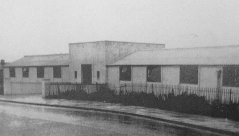
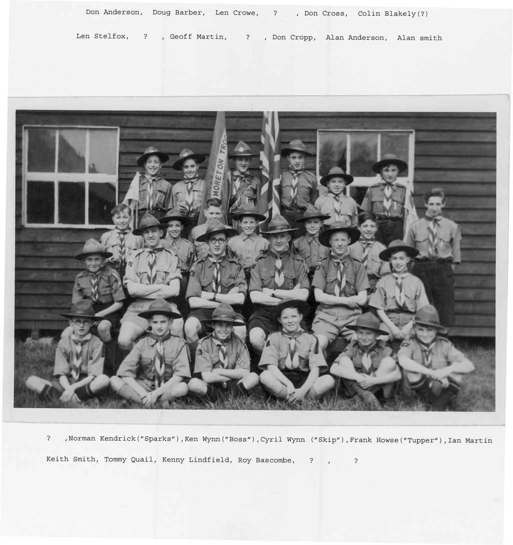
1948 photograph of the
2nd Moreton Scouts, taken outside the headquarters on Doreen Avenue. I
have identified many of the people in the photo but, whereas their faces
are still in my memory, their names have gone.The founders of the troop
were the Wynn brothers, Cyril being the initial troop leader although Ken,
who died quite recently, was in charge in the troop's latter years before
its dissolution. Frank Howse left to set up his own troop, but I know
little of that venture.
Recollections of Lingham Lane And Moreton - George Moor Some Leasowe kids were allocated to another school near Barnston Lane ... Paul Child tells me he was put in this school before BP transfer. As for the teacher - female, the name Bradbury does ring a bell. Looking at the photo I assume that they had intentionally kept the Leasowe kids together in one class. Maybe because of the bus timetables. Only Malcolm Blauel's face resurfaces in my Wally G photographs. I have just a few recollections - taking the wrong bus, 4 and 4a! - losing my fare for the return journey and the conductor letting me off with a wink, those massive sheets of white paper we folded and cut up for art, real tracing paper, those folded pieces of tissue kept in the top left pocket for 'emergencies', Brian Alexander showing me how to create and colour cool X strip patterns using graph paper .. and maniacally pulling a large tyred truck around outside. Yes, an aspiring Mr Bean then who at the age of 5 didn't think twice about using public transport. Try that today pal.. After reading about all the horrors of attending Primary School in those days (slashed patellas, lost finger tips, being blamed for breaking teachers arm (Barbara Tattum) , those one on ten stone chucking fights, falling into the figure of eight, (ponds on Fender Lane - mk) Routemaster bus journeys, etc I am far more ready not to question my daughter when she tells me she lets her four year old pupils romp outside in the snow . I'm still in
touch with about ten old Leasowe Moretonians. Several kids made good - Philip
Williamson (reeds lane) retired recently after heading up Nationwide, Geoff
Mckee ex Ceo of blacks now runs a clothing biz, Bill Henderson heads up Egon
Zehnder in HK - we were directors for Jardines in SE Asia for ten years, Allen
Gaskell is a well known musician who played with Benny king etc etc - now plays
the Mersey circuit and sends me daft emails, Eric Prince is head/prof of
dramatic arts, and a playwright Uni of Colorado... Alan Chesters has own biz -
designs massive stagesets - he did the Motorhead, Pink Floyd stuff... etc etc
etc The list goes on and is unusually long for corpie kids from new estates - I
guess the war years had gone and everyone was getting on with it those days.
I retired to UK after 20 yrs in Asia Pacific and have happily traded engineering
and construction for writing poetry and music.
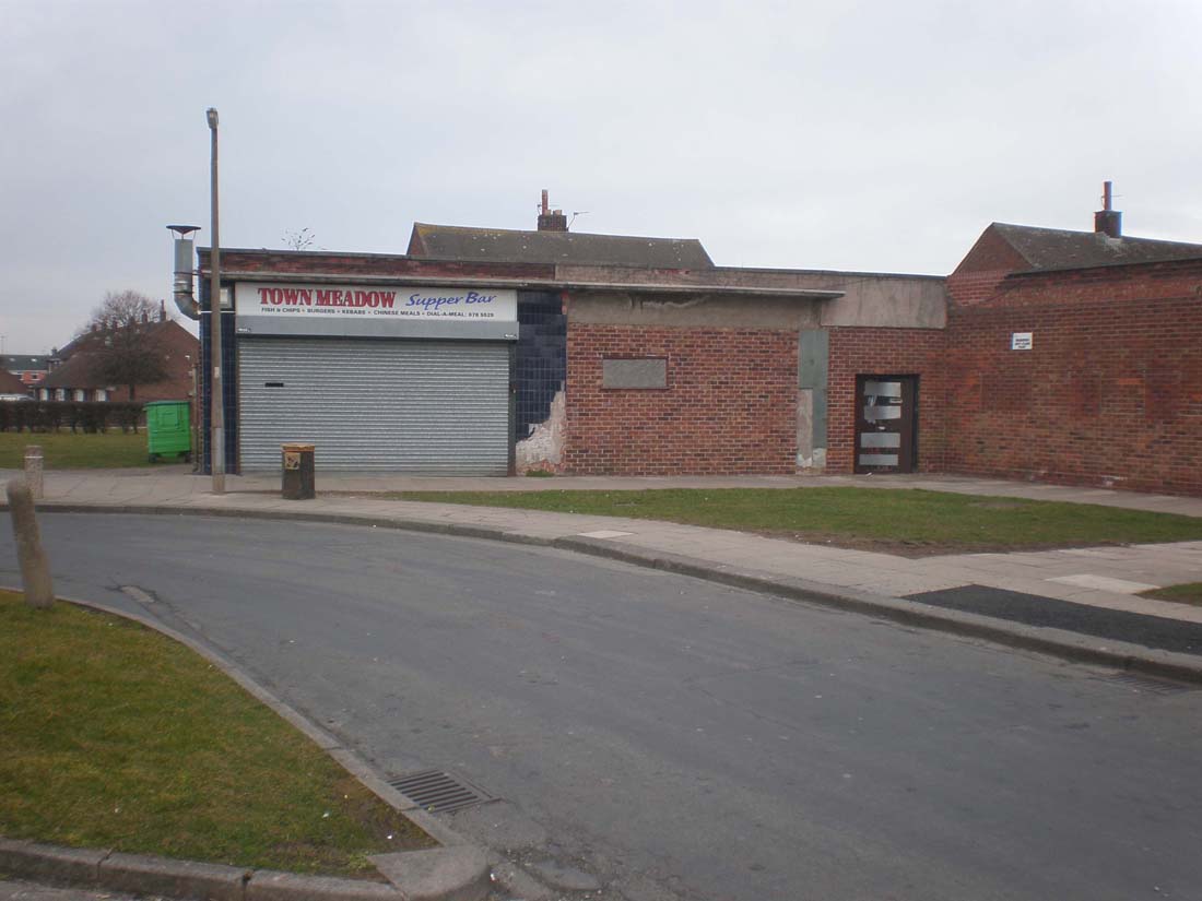
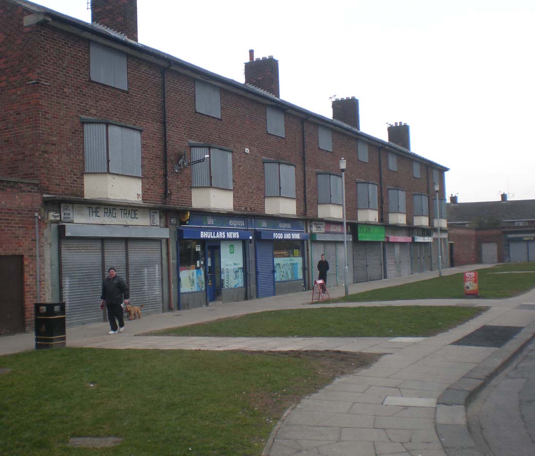
March 2010: Does anybody recall those shops in Town Meadow Lane? There was a block of them, with flats above, set near to the road leading around Lingham Park. Keith Norman recalls that there was a chippy - any others? I passed there, on foot, on many an occasion but never recall calling into them. On the 18th March 2010, I went into Moreton and took the following images of this now sorry state of affairs.
I went there with the original intention of asking present shop owners if they knew what was there in the 60s but as the only shop was an asian (sic!)general store, I didn't bother! I found out from Andrew Giliver that, in the early 60s, there was a greengrocer at one end, Nancy? Kilvington was the proprietor. Further along a chandlers, selling soaps, paraffin pegs and all sorts, quite an odorous shop. Skilbecks was a chemist, and there was a newsagent, and tobacconists. At the far end there was a butchers The Wirral Partnership Homes’ scheme – supported by a 500-name petition from the local community – is set to be approved by Wirral planning committee next month. The plan to house ex-offenders and drug addicts in the buildings at Town Meadow Lane, put forward by Wirral Labour Group in 2001, was scrapped following a public outcry. Moreton and Saughall Massie Cllr Chris Blakeley said: “It generated huge opposition from the local community.” From Gary Bates: I just thought I would like to add a bit more to what Paul Spencer says about Town Meadow Lane Shops. They were known as the New Shops but nicknamed “ The Newies” I lived at Number 84a which is the second to left flat in the picture. We moved there when i was 2yrs old in 1960 and stayed there until 1972. There were the Greenop family in the first flat (They emigrated to Australia but returned to Wallasey a few years later) Then us – then The Carlyles – then Norfalls - the Reids and Halls. Me and my older brother Alan spent many a happy hour with our mates playing “ headers” under the glass roof in front of the shops. And there was never any trouble. The lads all lived very close- some of the names – Alan Knott - Barry Nicholls - Billy Lewis – Graham Norman – David Picken – Keith Stirling – Geoff Platt. Happy Days!! From Gail Walters: We lived opposite the 'new shops' in Town Meadow Lane (as they were called in the late fifties and sixties). There was a chippy as you say, a chandler, off licence, sweet shop, butchers. A bit further along (towards Lingham Lane) there was M.A. Greens and I remember Mrs Green and her son running a kind of General Store with fruit and veg, sweets and lollies. Then round the corner in Wastdale Drive there was another General Store which I think was a Post Office too. Happy Days! |